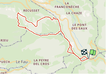
Trail Walking Le Falgoux - D17 Col de Redondet - Photo
 guariso
guariso

User

© OpenStreetMap contributors
Length
Length
22 km
Max alt
Max alt
1634 m
Uphill gradient
Uphill gradient
1035 m
Km-Effort
Km-Effort  
36 km
Min alt
Min alt
1176 m
Downhill gradient
Downhill gradient
1034 m
Boucle
Boucle
Yes
Creation date :
2014-12-10 00:00:00.0
Updated on :
2014-12-10 00:00:00.0

(0 Reviews)

Walking
Walking
6h00
Difficulty : Difficult

Scan this QR Code to open this trail in the SityTrail application

FREE GPS app for hiking

Logo SityTrail SityTrail

IGN / Geographical institutes

Download SityTrail from the App Store Download SityTrail from Google Play

Logo SityTrail SityTrail Plus

The world is yours!

Download SityTrail from the App Store Download SityTrail from Google Play Download SityTrail on Huawei AppGallery

About

Trail Walking of 22 km to be discovered at Auvergne-Rhône-Alpes, Cantal, Le Falgoux. This trail is proposed by guariso.

Description

Le départ se trouve dans le virage en épingle à cheveux, sur la D17 près du col de Redondet, près du Pas de Peyrol. Peu de places de stationnement donc il faut arriver tôt! Le parcours est long et malgré une apparente constante dans l'altitude il y a plus de 1000mètres de dénivelé cumulé; mais le paysage en vaut la peine. Partir par beau temps est le seul conseil à respecter; après tout est une question d'entrainement... Encore une fois le parcours est magnifique!

Elevation profile

Photos

Points of interest

Point of interest Le Falgoux - D17 Col de Redondet - Photo
guariso

Positioning

Country:
France
Region :
Auvergne-Rhône-Alpes
Department/Province :
Cantal
Municipality :
Le Falgoux
Location:
Unknown
Start:(UTM)
473427 ; 4994604 (31T) N.


Close
My subscriptions